Geography
·
Why 90% of Us Crowd the Same Spots
Easy
5 min
Why 90% of Us Crowd the Same Spots
Most of Earth is empty, and the reason why tells you everything about how humans actually work.
Share
Half of all humans alive right now live in a circle you could draw around Asia. The other half are scattered across the rest of the planet. Earth isn't crowded — it's just crowded in very specific places. Why?
Picture a map of Earth at night from space. You'd expect it to look evenly lit — 8 billion people spread across 57 million square miles of land. Instead, you get something that looks like someone spilled glitter on three or four spots and left the rest pitch black. The Nile Delta. The Indo-Gangetic Plain. Coastal China. Western Europe. Blazing bright. Then vast stretches — Siberia, the Sahara, the Amazon, the Australian outback — almost nothing. This isn't random. Every cluster of light is a place where something made it easy to stay alive. Every dark patch is a place that made it hard.
Make your call
Before we get into the mechanics: why do half of all humans cluster in that one Asian circle? What's the single thing those packed regions all have that the empty ones don't?
A
They have milder temperatures and more sunlight year-round
B
They have reliable fresh water and fertile soil for growing food
C
They developed stronger governments that encouraged settlement
The single biggest predictor of where people live is water — specifically, fresh water you can drink and farm with. Rivers don't just quench thirst. They deposit rich sediment that makes soil insanely productive. They power mills, carry trade, and connect cities. The Nile has been feeding Egyptian civilization for 5,000 years not because Egyptians got lucky, but because a river running through a desert is basically a cheat code. Same story with the Ganges, the Yangtze, the Rhine, the Mississippi. You want to find where people are? Find the rivers.
After water, the second biggest filter is climate. Not just temperature — the specific combination of warmth and rainfall that lets you grow food. The sweet spot is what geographers call a temperate climate: warm enough to farm most of the year, wet enough that crops don't die, cool enough that disease doesn't run rampant. This band of livable climate wraps around the mid-latitudes of both hemispheres. Drift too far toward the equator and you get brutal heat, flooding, and disease. Drift too far toward the poles and the growing season shrinks to almost nothing. The habitable middle is smaller than you'd think.
Key Insight
That's the answer to why half of humanity crowds the same circle: geography chose for them. Every dense population center on Earth sits on a combination of fresh water, farmable soil, and survivable climate. Remove any one of those three, and the city doesn't exist.
Example
Bangladesh is one of the most densely populated countries on Earth — roughly 170 million people packed into a space the size of Iowa. Why? It sits at the confluence of three massive rivers, the Ganges, Brahmaputra, and Meghna, which deposit some of the most fertile soil on the planet every monsoon season. Farmers have been able to grow multiple rice crops per year for millennia. The density isn't a modern accident. It's the result of thousands of years of people following the food. Now compare that to Mongolia, same rough latitude, but landlocked, dry, and cold. Mongolia has 3 million people in a space 7 times the size of Bangladesh. Same species, wildly different geography, wildly different outcome.
Industrialization started to break the rules. For most of human history, you had to live near food. Then we built railroads, refrigeration, and global shipping. Suddenly you could live in a desert if someone could truck water in. Las Vegas exists. Dubai exists. These places have millions of people in environments that would have been uninhabitable 200 years ago. But look closely and the old rules still whisper underneath. Even Las Vegas depends on the Colorado River. Even Dubai imports almost all its food. The geography hasn't changed — we've just gotten better at cheating it. For now.
Related threads
Geography
·
Why Two Cities at the Same Latitude Feel Worlds Apart
Why Two Cities at the Same Latitude Feel Worlds Apart
Geography
·
Every City Was Built Next to Water
Every City Was Built Next to Water
Sources
Images from Wikimedia Commons. Attribution required by license.
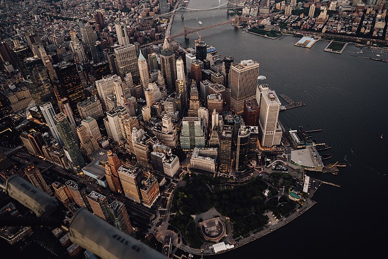
High-angle aerial view of the Financial District in Lower Manhattan, New York City, taken at dusk. The image shows the urban density of the skyscrapers along Water Street and State Street, leading down to Battery Park at the southern tip of Manhattan. The Whitehall Terminal (Staten Island Ferry) is visible on the right. In the background, the Brooklyn Bridge spans the East River, connecting Manhattan to Brooklyn.
SebastianBlumeArt · CC BY-SA 4.0
This composite image shows Earth's night lights as observed in 2016. The compositing technique selected the best cloud-free nights in each month over each land mass. The team has also reprocessed 2012 data with the new techniques so that researchers can compare and contrast light sources over the years. By late 2017, Román and colleagues hope to provide daily high-definition views of Earth at night.
NASA Earth Observatory images by Joshua Stevens, using Suomi NPP VIIRS data from Miguel Román, NASA's Goddard Space Flight Center · Public domain
Quiz yourself