Geography
·
Why Two Cities at the Same Latitude Feel Worlds Apart
Easy
5 min
Why Two Cities at the Same Latitude Feel Worlds Apart
The hidden forces that decide whether you need a parka or sunscreen
Share
London and Calgary sit at almost the same latitude. London barely gets snow. Calgary gets buried. Same distance from the equator, completely different worlds. Something else is running the show.
Latitude is the starting point — the closer you are to the equator, the more directly the sun's rays hit you. Direct sunlight means more energy per square meter, which means heat. That's why it's sweltering in Lagos and freezing in Reykjavik. But latitude is just the opening bid. Three other forces come in and completely rearrange the deal.
Picture the Earth tilted on its axis, with the equator as a belt around the middle. Sun rays hit the equator almost straight down — concentrated, intense, hot. Now trace a ray hitting near the poles: it arrives at a steep angle, spread thin across a huge surface area, like shining a flashlight straight at a wall versus at a 45-degree angle. Same flashlight, way less brightness per square inch. That angle difference is why every 1,000 km you travel toward a pole, average temperatures drop by roughly 6–7°C.
Now add altitude. The higher you go, the thinner the atmosphere — and thin atmosphere holds less heat. That's why Quito, Ecuador sits almost on the equator but has a permanently mild, spring-like climate. It's at 2,850 meters above sea level. The equatorial sun is blazing down, but the air is too thin to trap much of that warmth. The rule of thumb: for every 1,000 meters you climb, temperature drops about 6.5°C. A mountain is basically a shortcut to a different climate zone without moving your latitude at all.
Make your call
London and Calgary sit at the same latitude — so why does Calgary get buried in snow while London barely sees any? What's the main force overriding latitude here?
A
Calgary is farther inland, cut off from the warming influence of ocean currents
B
London is closer to the equator than it appears on most map projections
C
Calgary sits at higher altitude, so thinner air holds less heat
Example
The California Current runs cold water down the US West Coast from the north. San Francisco sits at roughly the same latitude as Madrid, Spain. Madrid hits 35°C in summer. San Francisco's famous for its summer fog and people wearing jackets in July. That cold offshore current chills the air coming off the Pacific before it reaches the city. Meanwhile, on the East Coast, the warm Gulf Stream runs northward — which is part of why New York's winters are brutal compared to the West Coast cities at the same latitude. Same country, same latitude band, wildly different climates. The ocean is calling the shots — which is exactly what's running the show between London and Calgary too.
Key Insight
Latitude sets the baseline. Altitude overrides it vertically. Ocean currents override it horizontally. These three forces don't take turns — they run simultaneously and compound each other. A high-altitude coastal city near a cold current can be dramatically cooler than a low-altitude inland city at the same latitude. Climate is not a single dial but three dials running simultaneously.
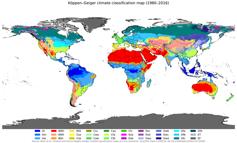
This is why climate maps look so jagged and weird instead of clean horizontal stripes. If latitude were the only factor, every city on the same parallel would have identical weather. Instead you get the Atacama Desert — the driest place on Earth — sitting right next to the Pacific Ocean, kept bone-dry by a cold current that kills rainfall. Or you get lush rainforests in places that 'should' be temperate, warmed by ocean currents that pump in tropical moisture. Once you see the three levers, every climate anomaly on the map starts making sense.
Sources
Images from Wikimedia Commons. Attribution required by license.
Global Köppen-Geiger climate classification (1980-2016)
Maulucioni, based on a previous work by Beck, H.E. et al. 2018 · CC BY-SA 4.0
insolation angle diagram sun rays latitude Earth
Generated by Grok Imagine (xAI), prompt: Generate a single 4:3 horizontal image for an educational lesson.
Lesson title: "Why Two Cities at the Same Latitude Feel Worlds Apart" · The hidden forces that decide whether you need a parka or suns…
Shuey, Sevilla Brace (Hayden) — Edith at Fort Point, looking at the Golden Gate Bridge in the fog, San Francisco, Calif. — 1956-09-01
Shuey, Sevilla Brace (Hayden) via Internet Archive (Internet Archive)
Quiz yourself