Geography
·
The Ground Beneath You Is Moving
Easy
5 min
The Ground Beneath You Is Moving
The solid Earth is constantly moving beneath your feet
Share
The ground under your feet is moving right now. Not shaking — just slowly, silently drifting. The continent you're standing on has been on a multi-billion-year road trip, and it's not done yet.
The Earth has a layer called the mantle that behaves like an incredibly slow liquid. Not water-slow. Not honey-slow. Think one inch per year slow. But when you have billions of years and unimaginable heat, even that snail's pace reshapes entire continents.
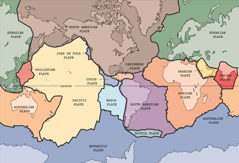
The outer shell of the Earth — the crust you live on — is broken into about a dozen massive slabs called tectonic plates. They float on top of the mantle like ice sheets on a very, very slow river. And they're constantly moving, colliding, grinding, and pulling apart.
Two hundred and fifty million years ago, there weren't seven continents. There was one — a supercontinent called Pangaea. Every landmass on Earth was jammed together in a single giant chunk.
Then the plates started drifting apart. South America and Africa split like two pieces of a torn photo — and if you look at a world map, you can still see how their coastlines fit together like puzzle pieces. That's not a coincidence. They were literally the same landmass until about 180 million years ago.
Make your call
Your continent has been drifting for billions of years. What actually keeps the plates moving — what's the engine driving all of this?
A
The Moon's gravitational pull tugging on the crust
B
Heat from the Earth's interior driving slow circulation in the mantle
C
The weight of the oceans pushing the seafloor outward
Key Insight
The Earth's surface is not a fixed stage that life plays out on. It IS the action. Every mountain range, every ocean, every earthquake zone exists because plates are moving — and have been moving for billions of years.
Example
Want to see plate tectonics in real time? Look at the Himalayas — the tallest mountain range on Earth. They exist because the Indian plate has been slamming into the Eurasian plate for about 50 million years. Two massive slabs of crust colliding head-on, with nowhere to go but up. The Himalayas are still growing today, about 5mm per year, because that collision hasn't stopped.
Or look at California. The San Andreas Fault is where the Pacific Plate and the North American Plate grind sideways past each other. Los Angeles is on the Pacific Plate. San Francisco is on the North American Plate. They're moving toward each other at roughly the speed your fingernails grow. In about 15 million years, LA will be a suburb of San Francisco.
Here's the part most people miss — most of the action happens underwater. The mid-ocean ridges, which run through every ocean on Earth, are where plates pull apart and fresh molten rock wells up to fill the gap. The Atlantic Ocean is getting wider by about 2.5cm every year because of this. Iceland literally sits on top of the Mid-Atlantic Ridge, which is why it has active volcanoes and can watch new land form in real time.
When plates collide and one dives under the other — a process called subduction — you get the deepest ocean trenches on the planet. The Mariana Trench, deeper than Everest is tall, exists because the Pacific Plate is diving under the Mariana Plate. The friction from that dive also creates some of the most violent earthquakes and tsunamis on Earth.
Key Insight
Earthquakes aren't random. They're almost entirely predictable in location — they happen at plate boundaries. The "Ring of Fire" around the Pacific Ocean is just a map of where plates are colliding. 90% of the world's earthquakes happen there.
Sources
Images from Wikimedia Commons. Attribution required by license.
English text version of Image:Tectonic plates (empty).svg
Tectonic plates of the Earth. From wikipedia.en, retrieved from USGS site: http://pubs.usgs.gov/publications/text/slabs.html
Original Image URL: [3]
Listed contact: mailto:jmwatson@usgs.gov
I uploaded a larger image made from the original illustrator file. —Ævar Arnfjörð Bjarmason 02:37, 19 Feb 2005 (UTC)
Map:USGS
Description:Muriel Gottrop~commonswiki · Public domain
Title: Aerial view of a portion of the San Andreas fault in California's Sierra Madre Mountains, midway between Bakersfield and Santa Barbara
Physical description: 1 photograph : digital, tiff file, color.
Notes: Title, date, and keywords provided by the photographer.; The geological fault runs roughly 810 miles through California. It forms the tectonic boundary between the Pacific Plate and the North American Plate.; Credit line: The Jon B. Lovelace Collection of California Photographs in Carol M. Highsmith's America Project, Library of Congress, Prints and Photographs Division.; Forms part of: Jon B. Lovelace Collection of California Photographs in Carol M. Highsmith's America Project in the Carol M. Highsmith Archive.; Gift; The Capital Group Companies Charitable Foundation in memory of Jon B. Lovelace; 2012; (DLC/PP-2012:063).
Carol M. Highsmith · Public domain
Quiz yourself